The United States of America is one of the largest and most diverse countries in the world. With 50 states, a wide range of geographic features, and multiple cultural regions, understanding the USA map can seem overwhelming. This guide will break it down for you — from the individual states and their capitals to the major regions that shape American identity.
📌 Introduction to the USA Map
The USA is located in North America and spans over 3.8 million square miles, making it the third-largest country in the world by total area. The nation is composed of 50 states, one federal district (Washington, D.C.), and several overseas territories.
Why Understanding the Map Matters
Knowing the layout of the USA map helps with:
-
Travel planning
-
Studying U.S. history
-
Understanding regional cultures
-
Educational purposes
-
Business and logistics
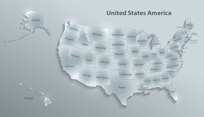
🗺️ The 50 States and Their Capitals
Here’s a list of all 50 U.S. states along with their capitals:
| State | Capital |
|---|---|
| Alabama | Montgomery |
| Alaska | Juneau |
| Arizona | Phoenix |
| Arkansas | Little Rock |
| California | Sacramento |
| Colorado | Denver |
| Connecticut | Hartford |
| Delaware | Dover |
| Florida | Tallahassee |
| Georgia | Atlanta |
| Hawaii | Honolulu |
| Idaho | Boise |
| Illinois | Springfield |
| Indiana | Indianapolis |
| Iowa | Des Moines |
| Kansas | Topeka |
| Kentucky | Frankfort |
| Louisiana | Baton Rouge |
| Maine | Augusta |
| Maryland | Annapolis |
| Massachusetts | Boston |
| Michigan | Lansing |
| Minnesota | Saint Paul |
| Mississippi | Jackson |
| Missouri | Jefferson City |
| Montana | Helena |
| Nebraska | Lincoln |
| Nevada | Carson City |
| New Hampshire | Concord |
| New Jersey | Trenton |
| New Mexico | Santa Fe |
| New York | Albany |
| North Carolina | Raleigh |
| North Dakota | Bismarck |
| Ohio | Columbus |
| Oklahoma | Oklahoma City |
| Oregon | Salem |
| Pennsylvania | Harrisburg |
| Rhode Island | Providence |
| South Carolina | Columbia |
| South Dakota | Pierre |
| Tennessee | Nashville |
| Texas | Austin |
| Utah | Salt Lake City |
| Vermont | Montpelier |
| Virginia | Richmond |
| Washington | Olympia |
| West Virginia | Charleston |
| Wisconsin | Madison |
| Wyoming | Cheyenne |
🌍 Regions of the United States
The United States is commonly divided into five or more major regions, each with distinct geography, culture, and economic activities. Here’s a breakdown of the most recognized divisions:
1. Northeast
-
Subdivisions: New England and Mid-Atlantic
-
States: Maine, New Hampshire, Vermont, Massachusetts, Rhode Island, Connecticut, New York, New Jersey, Pennsylvania
-
Key Features:
-
Known for historic cities like Boston and Philadelphia
-
Dense population and economic hubs
-
Cold winters, vibrant fall foliage
-
2. Midwest
-
States: Ohio, Indiana, Illinois, Michigan, Wisconsin, Minnesota, Iowa, Missouri, North Dakota, South Dakota, Nebraska, Kansas
-
Key Features:
-
Known as “America’s Heartland”
-
Agriculture and manufacturing are major industries
-
Flat plains and Great Lakes
-
3. South
-
Subdivisions: Southeast and Southwest
-
States: Delaware, Maryland, Virginia, West Virginia, North Carolina, South Carolina, Georgia, Florida, Kentucky, Tennessee, Alabama, Mississippi, Arkansas, Louisiana, Texas, Oklahoma
-
Key Features:
-
Warm climate
-
Rich in cultural heritage, especially music and food
-
Rapidly growing cities like Atlanta, Austin, and Miami
-
4. West
-
States: Montana, Wyoming, Colorado, New Mexico, Idaho, Utah, Arizona, Nevada
-
Key Features:
-
Mountain ranges like the Rockies
-
National parks and natural wonders (e.g., Grand Canyon)
-
Mixed climates: deserts, mountains, forests
-
5. Pacific
-
States: California, Oregon, Washington, Alaska, Hawaii
-
Key Features:
-
Coastal lifestyle and economic hubs (e.g., Silicon Valley, Seattle)
-
Earthquakes and volcanoes (Ring of Fire)
-
Hawaii’s tropical islands and unique Polynesian culture
-
🏛️ Washington, D.C.: The Federal District
Although not a state, Washington, D.C. is the capital of the United States. It serves as the seat of the federal government and is home to key landmarks like:
-
The White House
-
The U.S. Capitol
-
The Supreme Court
-
Numerous museums and monuments
🌐 Territories of the USA
The U.S. also controls five major territories:
-
Puerto Rico
-
Guam
-
U.S. Virgin Islands
-
American Samoa
-
Northern Mariana Islands
Residents of these territories are U.S. citizens or nationals, but they do not have voting representation in Congress.
🧭 Geographic Landmarks on the Map
When looking at the USA map, certain geographic features stand out:
-
Rocky Mountains – Western U.S., stretching from Montana to New Mexico
-
Appalachian Mountains – Eastern U.S., from Alabama to Maine
-
Mississippi River – One of the longest rivers in the world
-
Great Lakes – Five freshwater lakes along the U.S.-Canada border
-
Great Plains – Flat lands covering parts of the Midwest
-
Deserts – The Mojave, Sonoran, and Chihuahuan deserts in the Southwest
🧳 Tips for Memorizing the USA Map
-
Use Mnemonics: Create phrases to remember state names.
-
Puzzle Games: Online interactive maps are a fun way to learn.
-
Flashcards: Test yourself with state names on one side and capitals on the other.
-
Songs and Rhymes: Several catchy tunes list all 50 states.
-
Group by Region: Learn in clusters (e.g., all New England states together).
📚 Fun Facts About U.S. States
-
Alaska is the largest state by area but one of the least populated.
-
Rhode Island is the smallest state by area.
-
California has the highest population.
-
Florida has more coastline than any state except Alaska.
-
Texas was an independent country before joining the U.S.
🧭 Conclusion
Understanding the USAmap isn’t just about memorizing names and capitals—it’s about appreciating the vastness and diversity of the country. From snowy peaks to sunny beaches, bustling cities to quiet plains, each state and region has its own story. Whether you’re a student, traveler, or curious learner, mastering the USA map opens up a deeper appreciation for this complex and fascinating country.